
Introduction
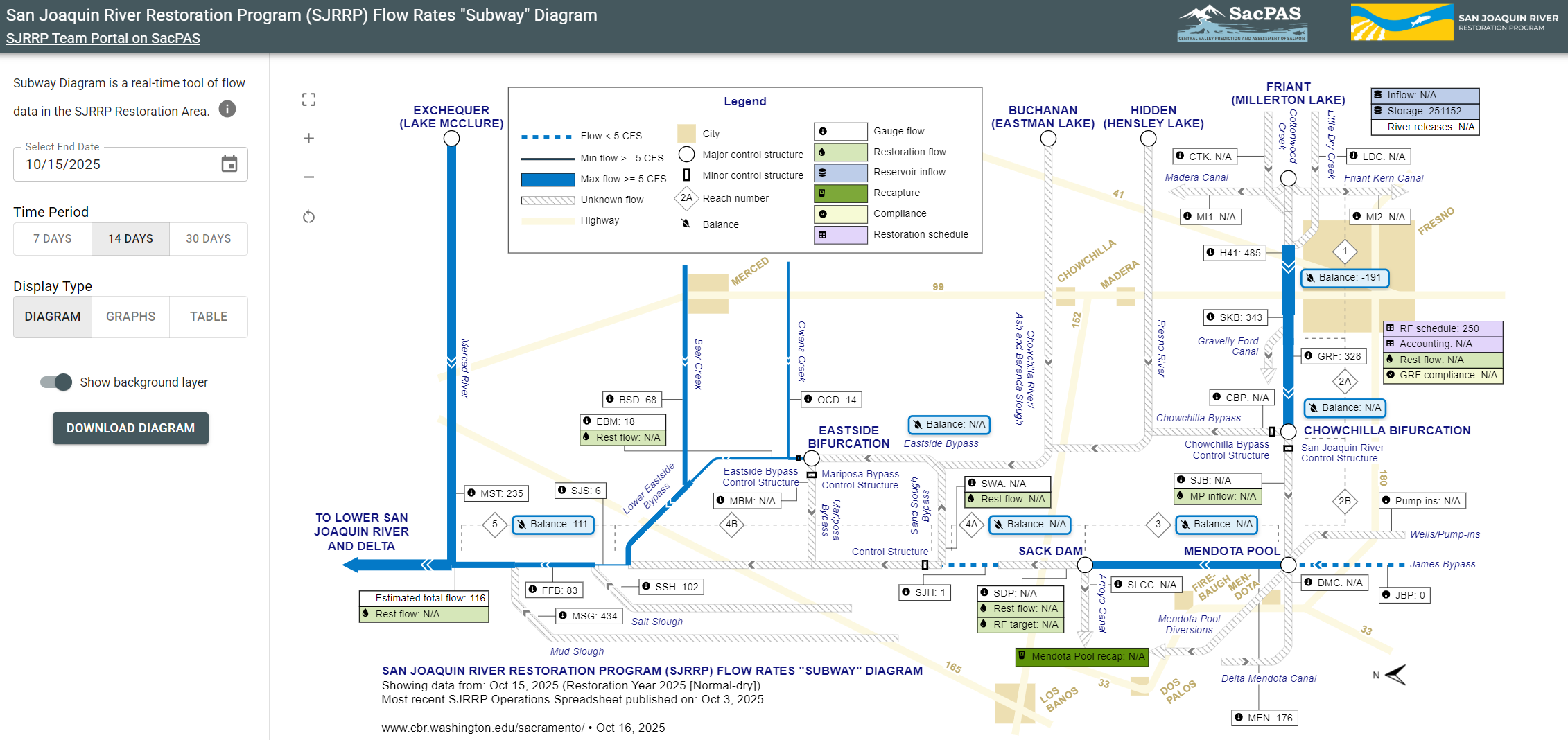
The San Joaquin River Restoration Program (SJRRP) aims to restore a Chinook Salmon fishery to the 152 miles of river channel between Friant Dam and the confluence with the Merced River (Restoration Area). Flow rates are depicted in the Flow Rate "Subway" Diagram, with SJRRP Restoration Flow rates depicted at key gauging locations (shown in green). These Restoration Flows are protected in-stream for fish and wildlife and should not be diverted except for recapture authorized by Reclamation.
Methods
Above Merced Calculation
The "Above Merced Confluence" uses flow rates from multiple sites to estimate the flow. The multi-site flow estimate is defined as the lesser of:
- SMN or
- Combination Sites calculation, which is the greater of:
- NEW - MST,
- FFB + MSG(1 day prior), and
- SJS(1 day prior) + SSH(1 day prior) + MSG(1 day prior).
When a value is missing for combination sites calculations 2b or 2c, the missing value for an individual site is ignored (i.e., treated as 0).
Reach Balance Calculations
Reach Balance calculations use daily average flow (cfs) from multiple sites to estimate the loss or gain in each reach.
Reach 1: Friant Dam to Gravelly Ford
Reach 1 daily balance is equal the daily average flow (cfs) at GRF (downstream location) for the day minus the daily average flow (cfs) at MIL (upstream location) 3 days prior. Thus, water travel time is estimated across a 3-day moving window for this reach.
Reach 2A: Gravelly Ford to Bifurcation
Reach 2A daily balance is equal to the daily average flow (cfs) at SJB (downstream location) for the day minus the daily average flow (cfs) at GRF (upstream location) 1 day prior. Thus, water travel time is estimated across a 1-day moving window for this reach.
Reach 2B+3: Bifurcation to Sack Dam
Combined Reach 2B and Reach 3 daily balance is equal to the daily average flow (cfs) at SDP (downstream location) for the day minus the daily average flow (cfs) at SJB (upstream location) 1 day prior. Thus, water travel time is estimated across a 1-day moving window for this reach.
Reach 4A: Sack Dam to Head of 4B/ Sand Slough Bypss
Reach 4A daily balance is equal to the daily average flow (cfs) at SWA (downstream location) for the day minus the daily average flow (cfs) at SDP (upstream location) 1 day prior. Thus, water travel time is estimated across a 1-day moving window for this reach.
Eastside Bypass: Sand Slough Bypass to Stevinson
Eastside Bypass daily balance is equal to the lesser of the daily average flow (cfs), at SJS (downstream location) for the day or at EBM (mid-reach location) one day prior, minus the daily average flow (cfs) at SWA (upstream location) 3 days prior. Thus, water travel time is estimated across a 3-day moving window for this reach.
Reach 5: Stevinson to Merced River Confluence
Reach 5 daily balance is equal to the daily average flow (cfs) multi-site calculation for "Above Merced Confluence" (downstream estimate) for the day minus the lesser of daily average flow (cfs), at SJS (upstream location) 1 day prior or at EMB 2 days prior.
Flow Sites Table
| Location Name | Site Code with Metadata link | Reach Balance | Source | County | Operator |
|---|---|---|---|---|---|
| San Joaquin R, Friant Dam (Millerton) (MIL) | MIL |
Reach 1 | CDEC | Fresno | US Bureau of Reclamation |
| San Joaquin R at Gravelly Ford (GRF) | GRF |
Reach 1, Reach 2A |
CDEC | Fresno | US Bureau of Reclamation |
| San Joaquin R, blw Bifurcation (SJB) | SJB |
Reach 2A, Reach 3 |
CDEC | Madera | US Bureau of Reclamation |
| San Joaquin R, near Dos Palos (SDP) | SDP |
Reach 3, Reach 4A |
CDEC | Fresno | CA Dept of Water Resources/South Central Region Office |
| San Joaquin R, Washington Road (SWA) | SWA |
Reach 4A, Eastside |
CDEC | Merced | CA Dept of Water Resources/South Central Region Office |
| San Joaquin R, Eastside Bypass blw Mariposa (EBM) | EBM |
Eastside, Reach 5 |
CDEC | Merced | CA Dept of Water Resources/South Central Region Office |
| San Joaquin R, Stevinson (SJS) | SJS |
Eastside, Reach 5 |
CDEC | Merced | CA Dept of Water Resources/South Central Region Office |
| San Joaquin R, Salt Slough (SSH) | SSH |
Reach 5, Above Merced Confluence multi-site estimate | CDEC | Merced | US Geological Survey |
| San Joaquin R, Fremont Ford (FFB) | FFB |
Reach 5, Above Merced Confluence multi-site estimate | CDEC | Merced | US Geological Survey |
| San Joaquin R, Mud Slough (MSG) | MSG |
Reach 5, Above Merced Confluence multi-site estimate | CDEC | Merced | US Geological Survey |
| San Joaquin R, near Newman abv Merced R (SMN) | SMN |
Reach 5, Above Merced Confluence multi-site estimate | CDEC | Stanislaus | US Geological Survey |
| Merced R near Stevinson (MST) | MST |
Reach 5, Above Merced Confluence multi-site estimate | CDEC | Merced | CA Dept of Water Resources/South Central Region Office |
| San Joaquin R, near Newman (NEW) | NEW |
Reach 5, Above Merced Confluence multi-site estimate | CDEC | Merced | US Geological Survey |
Data Notes
- San Joaquin River Restoration Program website.
- Restoration Year is from March 1 through end of February the following year.
- Data extracted from SJRRP Operations spreadsheet provided by USBR.
- Where available, data courtesy of CDEC between the most recent SJRRP Operations spreadsheet data and yesterday are used.