Data & Alerts
Explore by Data Type
Visualizations for Fishes
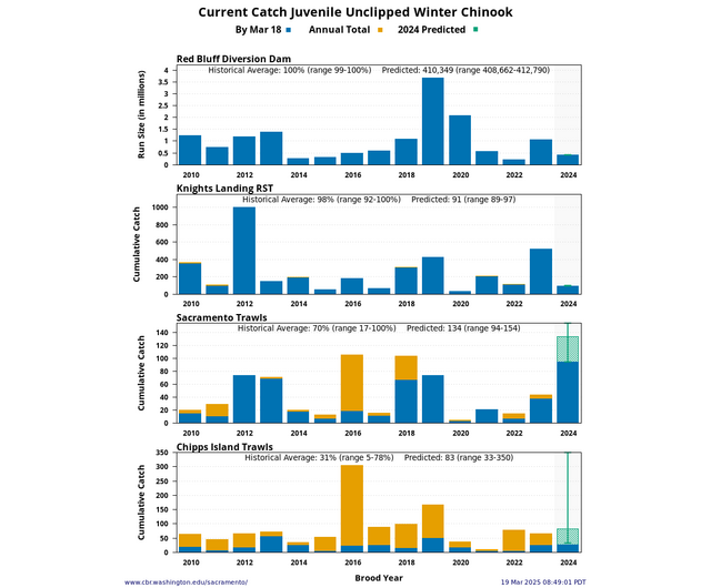
Presents Red Bluff Diversion Dam, Knights Landing, Sacramento Trawls, and Chipps Island Trawls catch for unmarked Winter Chinook, Spring Chinook, Fall Chinook, Late-Fall Chinook, and Steelhead. Predicted total of Current Catch based on 15 year average timing and percent. Updated daily. Carousel figure 1.
Presents Older Chinook, Smolt/Fry Chinook, and steelhead juvenile salmonid monitoring at rotary screw traps, beach seines, and trawls for Sacramento River (Red Bluff Diversion Dam and Tisdale RST), Lower Sacramento River (Knights Landing RST, Sacramento Trawls, Sacramento Beach Seines, and Chipps Island Trawls), and San Joaquin River (Mossdale Trawls) with Temperature, Flow and Turbidity. Updated daily. Carousel figure 2.
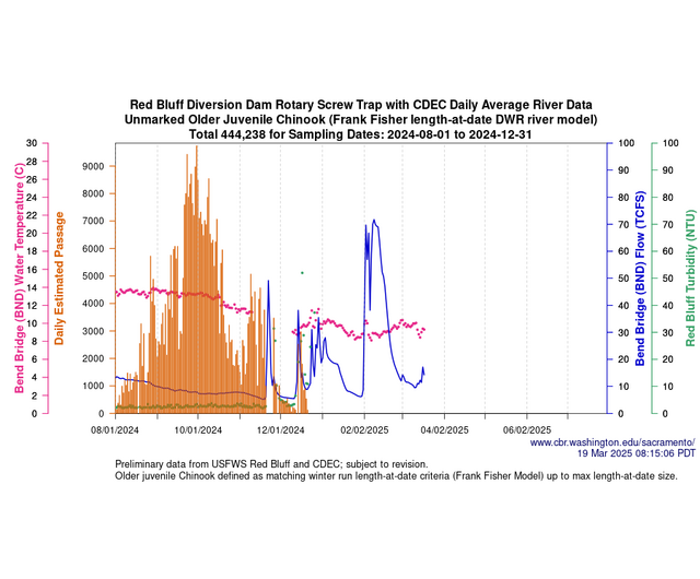
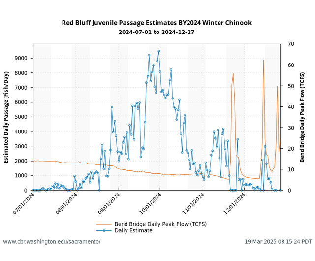
Presents Red Bluff Diversion Dam daily passage estimates with optional Biweekly Estimated Totals, Fork Length, Flow, Turbidity, and Water Temperature. Updated daily. Carousel figure 3.
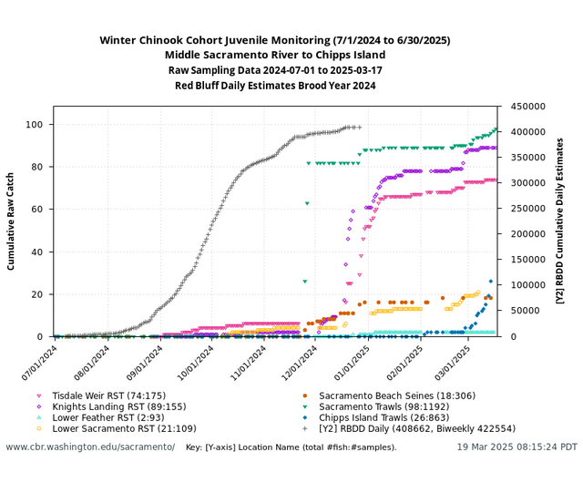
Presents brood year cohort monitoring for juvenile Chinook and steelhead at Sacramento River rotary screw traps, beach seines, and trawls with Red Bluff passage estimates. Updated daily. Carousel figure 4.
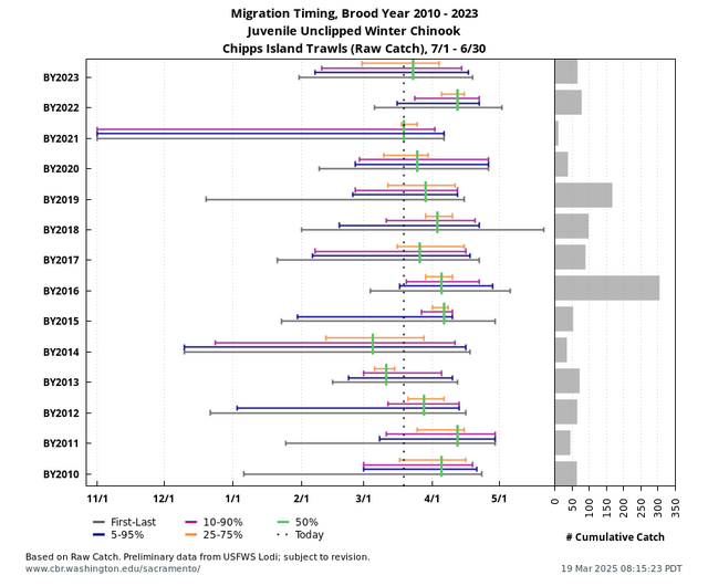
Presents historical migration timing for juvenile Chinook and steelhead at Red Bluff, Sacramento River rotary screw traps, beach seines, and trawls with hydrological conditions. Carousel figure 5.
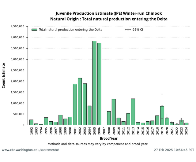
Presents Total natural production entering the Delta for natural origin Winter-run Chinook from JPE Letter. Updated annually. Carousel figure 6.
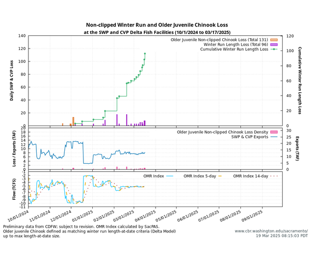
Presents calculated loss for non-clipped and clipped Older Chinook, Fry/Smolt Chinook, and Steelhead at SWP and CVP Delta Fish Facilities with OMRI flows, additionally Day/Night Sampling Patterns. Updated daily. Carousel figure 7.
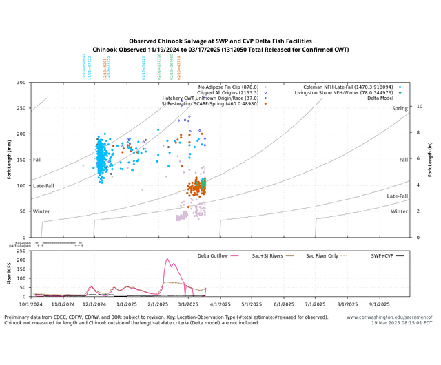
Presents salvage of non-clipped and clipped Chinook and Steelhead at SWP and CVP Delta Fish Facilities with flows. Chinook includes forklength and confirmed CWT origin. Updated daily. Carousel figure 8.
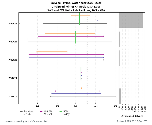
Presents historical Salvage Timing at SWP and CVP Delta Fish Facilities with Cumulative Salvage and Timing Characteristics. Updated daily. Carousel figure 9.
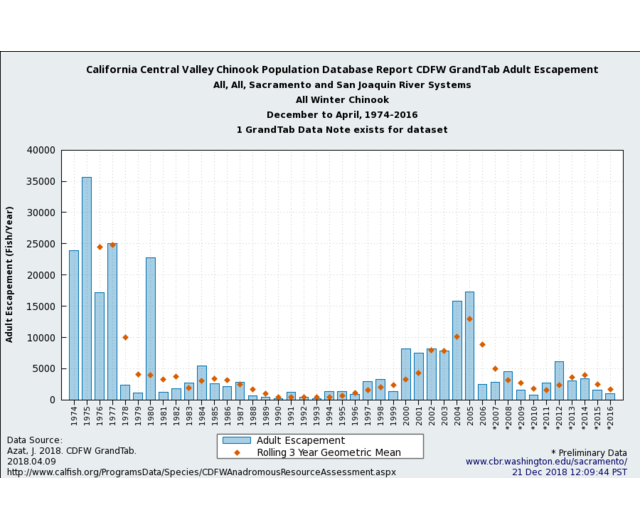
Presents the CDFW GrandTab, California Central Valley Chinook Escapement Database. Updated annually. Carousel figure 10.
Visualizations for Environment
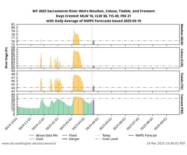
Presents River Stage (ft) above / below Weir Crest Level at 4 Sacramento River Weirs — Moulton, Colusa, Tisdale and Fremont — with NWPS forecasted levels. Updated daily. Carousel figure 1.
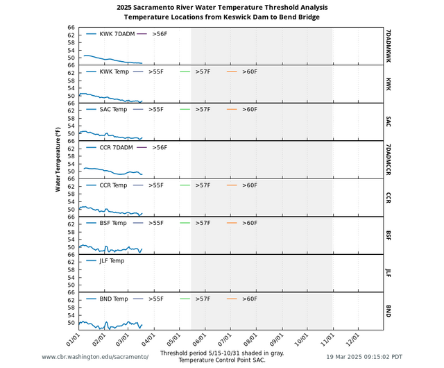
Presents Sacramento River Water Temperature from Keswick to Bend Bridge with color coding for daily threshold values (°F). Updated daily. Carousel figure 2.
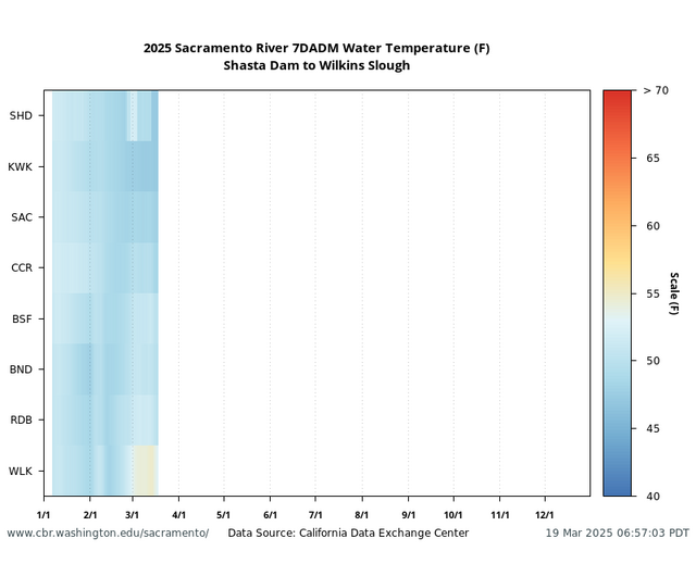
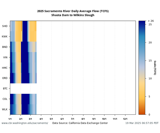
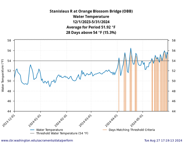
Presents basin conditions for Sacramento River Shasta Dam to Wilkins Slough. Examples show 7 day average of the daily maximum (7DADM) water temperature (°F) and flow. Updated daily. Carousel figures 3 and 4.
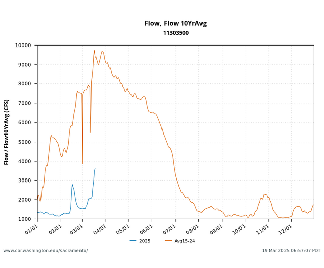
Presents current river flow with the ten year average for San Joaquin River near Vernalis (USGS: 11303500). Query allows for selection of multiple years, multiple locations, and multiple parameters as specified by the user. Updated daily. Carousel figure 5.
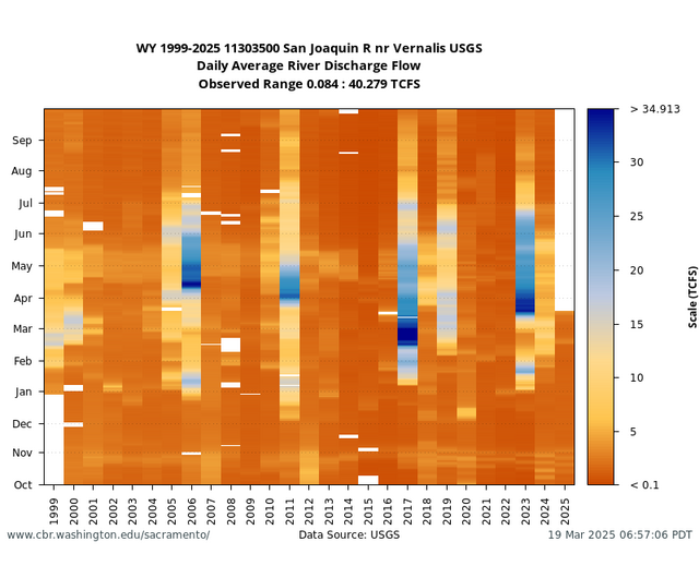
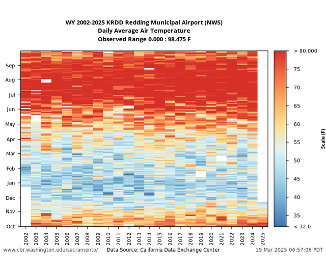
Presents the full historical dataset to current day for a single location and data parameter as a heatmap plot for comparison across water year, month, and value, and inter-annually (vertically). Scale options are provided for user-specified thresholds. Updated daily. Carousel figures 6-9.
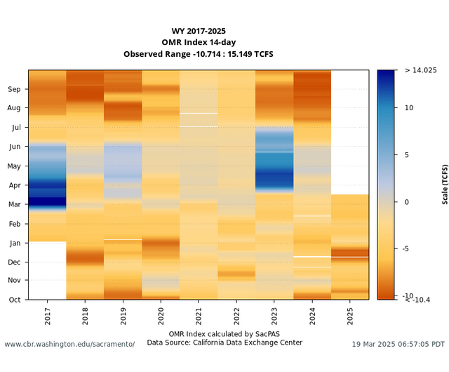
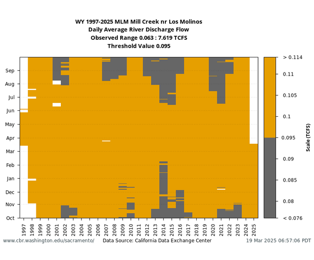
User-specified threshold analysis of observed River Conditions at locations in the Central Valley — Sacramento River Basin, San Joaquin River Basin, and Delta. Updated daily. Carousel figure 10.